Keep up with our latest news and projects!
In the redevelopment of an open urban public space, we look to include not only its general functional and symbolic significance for the city, but also its integration into the local urban fabric. In the context of urban design, this involves the demarcation of the area surrounding a public space by identifying it as the area of its local integration. Depending on successive stages of urban design, the mode of identification and demarcation of such an area may differ. For example, when it is about: (a) identifying the site’s surroundings through social considerations of local inhabitants’ characteristics, (b) dealing with land use changes in areas adjacent to the site under development, considering various types of stakeholders, users and activities, or (c) addressing the adaptation to the reality of the public space through the activities of a wide range of users and actors related to the specific site. Furthermore, different perceptions may be associated with a multitude of representations, meanings and processes related to urbanity and social mix.
The significance of a redeveloped open space in the urban fabric is visible in the essential characteristics of its local social mix and of its surroundings with regard to urbanity and heterogeneity, as seen by Wirth (1964/1938). Consequently, the urban development process has to take into account the variations between different cities as well as between different urban areas of the same city. With this view in mind, when approaching the city as a place where everyone feels at home, it is important to explore the daily rhythms of collective life in the city and in the specific area. This aspect is primarily related to the inclusiveness of people and the activities of various user groups (daily users, customers, occasional visitors, or potential users and non-users). Likewise, inclusiveness related to everyday life implies investigations during various seasons and times when the structure of the population and the habits of local residents harmonize with the rhythms of the city’s daily routines.
The work presented here explores how people, having a strong tie with a public space, identify and demarcate its surrounding area of integration in the urban environment. This was one of the goals of a field survey carried out in four squares in central Athens. The exploration showed that the four squares have a common area of local integration, which is distinct inside central Athens.
This result differs significantly from the views expressed in the current strategic regeneration programmes and plans for the city of Athens. Therefore, it is proposed here to connect concrete spatiality with representations based on perceptions, experiences and views of users, active actors and residents. In the wider context of urban design and development, the concrete spatiality is associated with topics such as centrality, attractiveness, influence, scale, configuration, concentration, and connectivity as well as high density, variety of economic activities, amenities and facilities, daily life, urbanity and lifestyles. These topics have been extensively discussed and experimented with in the urban design (and previously in the architecture or city planning) literature and praxis, with a focus on open public spaces (streets, squares, railway stations, gardens, monument front places, etc.) as well as in the social and human studies as multifaceted issues linked to the population of the city and of specific urban areas.
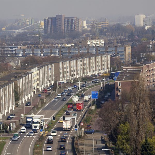
The sites selected for the field survey were the squares Omonia, Kotzia, Varvaki and Monastiraki in the central area of Athens, which were redeveloped from the 1980s to the 2000s. The four squares are adjacent to each other and follow one another along the axis of Athena Street in the direction of the old town. These squares represent one of the five case studies in the broader project and they are a key case in applied urban design in Athens.
Interviewing the people working in the plinths
The field survey has been based on a structured questionnaire that was administered to people working on the ground floors, around and across the squares. The idea was to capture the interviewees’ perceptions of the squares during everyday life after their redevelopment, as well as of general issues concerning public space. Completion of the questionnaire was achieved in 53% of the existing premises that were recorded during the survey preparation phase in 2016.
Revealing intimate city knowledge
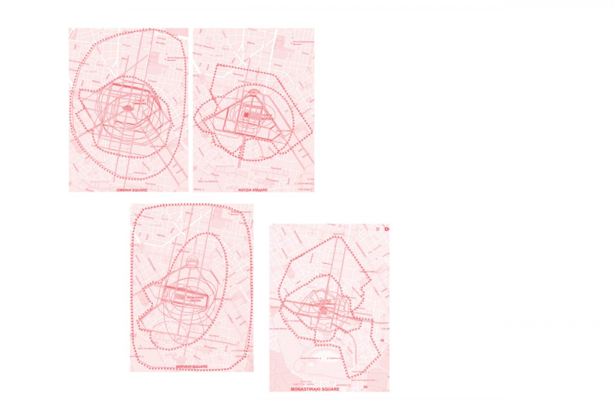
In order to identify the areas of integration of the four squares into the local urban fabric in relation to daily life of squares, a special three-part open question was included in the questionnaire. Interviewees were asked to characterize and describe, according to their opinions, the surrounding area to which each one of the four squares belonged as well as the important roads of this area and, finally, to use the map included in the questionnaire to demarcate the area based on their knowledge and experiences. The respondents appeared to have a privileged perception and knowledge of the changes the squares have undergone.
Rich and diverse merchants with strong ties to the squares
As group of actors, they have had a strong link with the squares over time and have contributed significantly to maintaining the human scale in the densely built urban environment with the kind of business they are associated with. The vast majority run small or micro businesses (80%) and only a few of them large or even medium-sized ones. Most of them are commercial establishments of various kinds: more than half are shops, restaurants, cafes, professional workshops, hotels, offices, banks, night clubs, religious establishments, public transport, public administration and a research institution. Furthermore, some of the establishments have been there since the 1900s. The operational structure of these businesses, whose owners form the majority of questionnaire respondents, reinforces the link between the target group and the public space of the squares. The owners are present on a daily basis in their workplaces, which are also places of professional responsibility and creativity. Personal communication, exchange and the interaction of their clientele with the broader users of the public space and the immediate physical proximity contribute to the personal experience of the challenges and functions of the public space (Avdelidi, 2018 upcoming).

For their development, in the context of applied urban design interventions and current planning strategies, the four squares are attached to various urban areas, which mostly do not overlap. More specifically, on a city scale, the design of two of the four squares (Omonia and Monastiraki) was part of the broader project for the unification of archaeological sites in Athens by means of architectural competitions.
The aim was to contribute to the recovery of the historical, architectural and urban physiognomy of the city by showcasing archaeological and cultural reserves, i.e. open public spaces, and by creating a grid of pedestrian roads within an open-air museum matrix connected to the contemporary fabric and daily city life. These squares were also part of the Attiko Metro project for redesigning traffic flows at metro and electric railway terminals and feeders. Kotzia and Varvaki squares were designed and refurbished as punctual interventions under the initiative of the City of Athens primarily in order to resolve parking problems in the city centre and to control the organization and functioning of the squares. This was part of a wider and ongoing process (since 1980) to regenerate the historic centre.
The development of the four squares involved radical spatial and morphological changes to their scale and limits, through architectural design and pedestrianization, in order to maximize the opportunities for collective activities and the contribution to community life at the neighbourhood level. On the other hand, based on data and spatial demarcations of the Statistical Service, at the scale of the local social fabric, the four squares are part of a single area, whose primary characteristic is the large population of self-employed citizens.
However, based on the internal socio-demographic similarities of the population, the area seems to be divided in two sub-areas, marked by both common and different characteristics.
Omonia and Kotzia squares
First sub-area, with the allowable land uses being the supra-local centre and general housing. Its population has a very strong male representation and a clearly globalized composition, with a very large share of poorly educated, single, blue-collar workers, economically active, members of large households, living in the poorly-maintained blocks of flats built in the period 1960-80.
Varvaki and Monastiraki squares
The second sub-area, with the allowable land uses being general housing, urban green or free spaces and the supra-local centre. Its population does have a male-gendered, globalized composition (though clearly much less so), the same degree of single and economically active individuals, while the composition is mixed in terms of educational level, with the presence of both highly and poorly qualified people. In the whole of the area, there is a very large proportion of young people, and people of active labour force ages (aged 15-24 for the first sub-area and 25-64 for the second one), whilst there are very low percentages of children (aged 0-14 for both sub-areas).
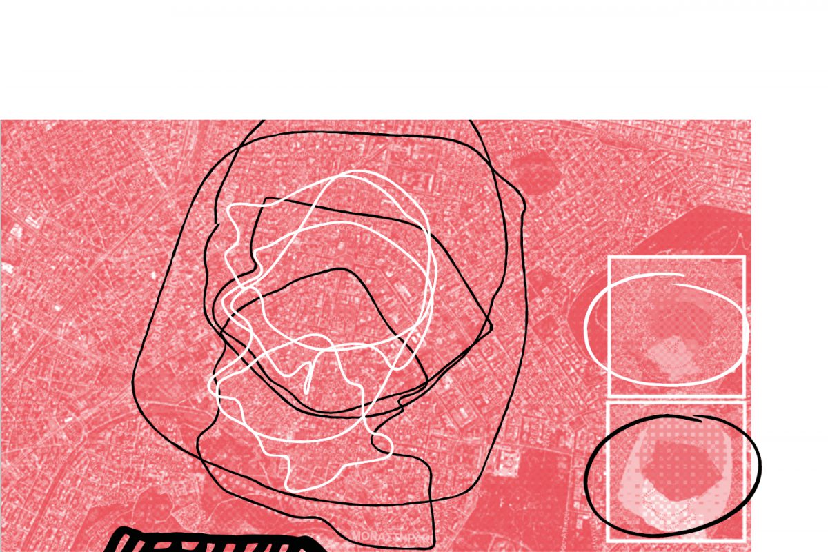
The analysis methodology involved the graphic synthesis of all answers, which led to the maps in Figure 1. It should be noted that the mapping corresponds to the respondents’ knowledge of the public space and its everyday uses, acquired through being present there every day, at the same space as the users, on ground level. Thus, the cartographic analysis of Figures 1 and 2 reflects the perceptive and active evaluation of reality. The findings clearly show the demarcation of the four central squares and their surrounding areas as a distinct unit in the centre of the city of Athens. This unit has to be taken into account by urban design research and practice precisely as a ‘locality identity’ within the central area of Athens, a wider area than the squares’ delimited public space, unifying them and distinguishing them from the commercial centre and the old town.
The integration of a public space in the urban fabric requires engagement with its surroundings and development of local ties. From a general point of view, the consideration of daily life and urbanity raises the issue of quotidianity in the sense of Lefebvre (1968), of routine, and of the ordinary as seen by Habraken (1998) as a set of “minor” activities confronted or intertwined with the extraordinary, which touches upon the historical, the philosophical. The generation or redevelopment of a public space is part of larger scale interventions in the city; however, every public space is organically related to its surrounding area on a constant, on-going basis.
From a more concrete point of view, in the case of the specific central squares in Athens, the punctual urban development interventions did not strengthen the local ties. From the field survey results the degradation of squares and of their surrounding area was largely associated with the lack of local square integration. Thus arose the necessity to ask users, entrepreneurs, active actors and residents to directly identify and demarcate, through their perceptions, the local integration of a public space before and after its use and function changes as a result of an urban design intervention.